Last updated August 18, 2020 at 2:58 pm
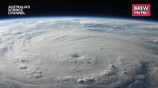
Landsat 8 caught this image of Western Australia’s Lake Carnegie filled with water following record breaking rainfalls during summer 2019-2020.
Lake Carnegie in Western Australia with water following the wet 2019-2020 summer. Click to enlarge. Credit: Landsat 8/NASA/US Geological Survey
One of the best sights in outback Australia is when normally dry lakes fill after heavy rains. Usually dry desolate places, the sudden influx of water completely changes the landscape, and birds flock to the area to breed. And that moment was captured in these images of the ephemeral Lake Carnegie, in Western Australia.
A zoomed image of Lake Carnegie filled with water. Credit: Landsat 8/NASA/USGS
Normally a muddy marsh, Lake Carnegie is different to many other dry lakes in that it is not fed by defined rivers. Instead it fills as a result of monsoonal rain and tropic cyclones drenching the area. These images were captured after the particularly wet 2019-2020 summer, when several rain events, including ex-Cyclone Blake hit the area. On 11 January 2020 alone, Carnegie Station received 270mm of rain as a result of Blake – close to a 1 in 1000 year event and the highest rainfall since records began in 1942. Overall, rainfall amounts in Western Australia were 9 percent above the average summer.
These images were captured by the Operational Land Imager (OLI) on Landsat 8 on 26 March 2020. The lakes were still partially full following those downpours.
The OLI captures images in the visible, near infrared, and short wave infrared portions of the spectrum.
There is uncertainty around how climate change will affect tropical cyclones in Australia, however most models project a reduced number. However, the proportion of high-intensity tropical storms is expected to increase, and rainfall intensity is also expected to increase.
When full, Lake Carnegie covers 5,714 square kilometres of the Shire of Wiluna in central WA, making it one of Australia’s largest lakes.
Courtesy of NASA Earth Observatory